
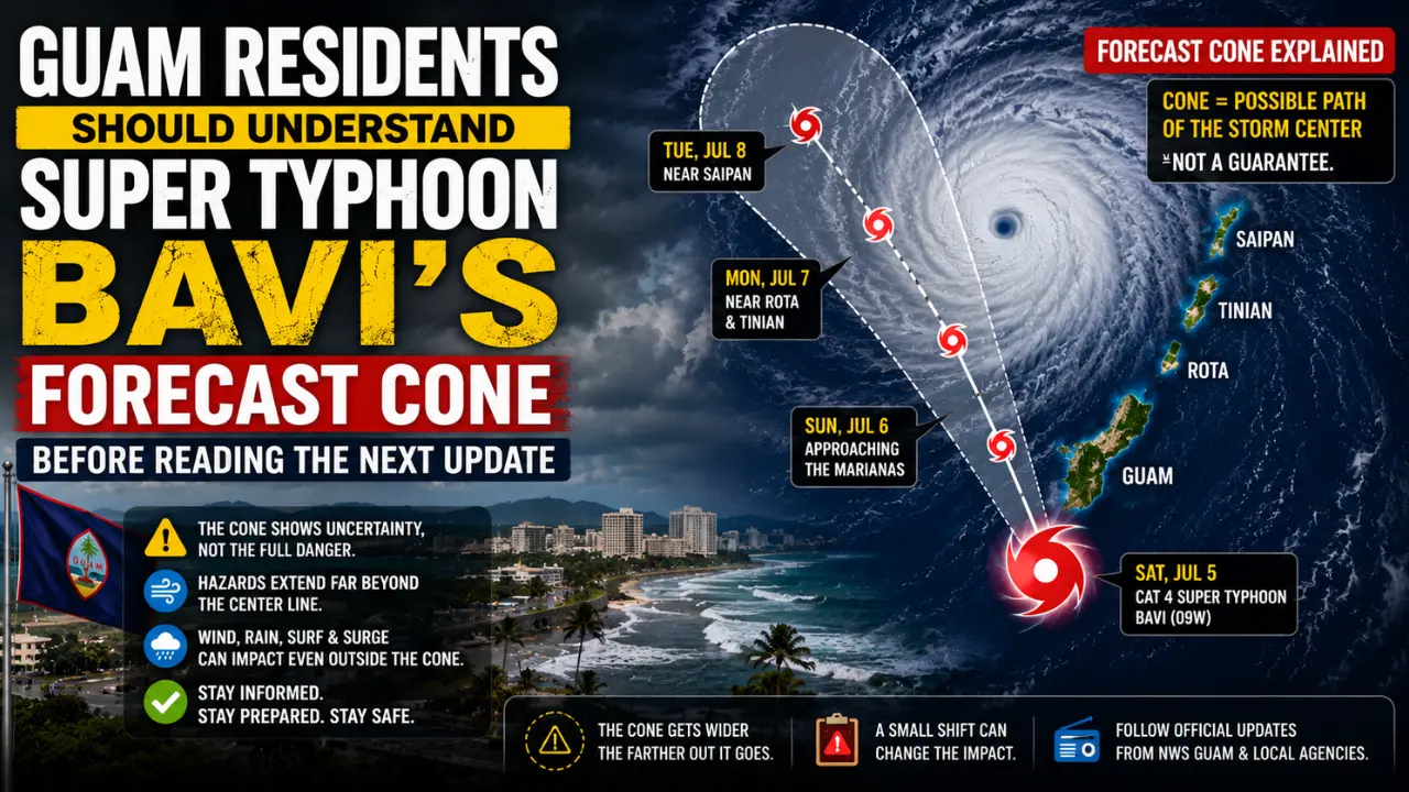

Super Typhoon Bavi’s track is one of the most important things people in Guam and the Northern Marianas are watching, but it is also one of the easiest things to misunderstand. Many readers look at a storm map and focus only on the center line, as if that thin line alone decides who is safe and who is in danger.
That is not how a powerful typhoon works.
As of the National Weather Service Guam local statement issued at 4:13 PM ChST on Sunday, July 5, 2026, Super Typhoon Bavi was a very dangerous Category 4 super typhoon moving west-northwest toward the Marianas, with typhoon warnings in effect for Guam, Rota, Tinian, and Saipan. The same statement said the forecast track still showed Bavi passing somewhere near or north of Rota, but there was still time for the track to shift north or south.
That one detail matters because a small track shift can change which island receives the worst eyewall winds, the highest storm surge, and the most destructive conditions.
Forecast Line Is Not the Whole Storm
The biggest mistake people make with typhoon maps is treating the forecast line as the storm itself. The line usually shows the expected movement of the center, not the full area of danger.
A super typhoon is much larger than its eye. Its rainbands, wind field, coastal surge, and dangerous surf can affect places far away from the exact center. That is why an island can avoid a direct eye passage and still receive damaging winds, flooding rain, high surf, and power outages.
The National Hurricane Center explains that a forecast cone represents the probable track of the center of a tropical cyclone. It does not mean hazards are limited to the cone or the center line. The cone is built around past forecast errors and shows uncertainty in the storm center’s future position, not the full size of the storm’s impacts.
For Guam, this is especially important. If Bavi passes near or just north of Rota, Guam may avoid the storm’s most violent core. But Guam can still experience strong tropical-storm-force winds, coastal flooding, heavy rain, and dangerous surf. If the track shifts south, Guam’s risk can increase quickly.
Before making safety decisions, residents should look at Bavi’s possible danger for Guam because wind, rain and surf can spread beyond the eye.
Why a Small Shift Can Make a Big Difference
A super typhoon has different danger zones. The worst winds are usually concentrated near the eyewall, while rainbands and rough seas can spread much farther. Because of that structure, a small change in the center’s path can make a major difference for one island and a smaller difference for another.
For Bavi, the National Weather Service said the forecast track maintained passage near or north of Rota, but it also warned that the track could still shift north or south. It stated that all islands would experience impacts, with damaging tropical storm conditions expected at minimum, while catastrophic damage would be possible near the center of the storm.
This means people should not think in simple yes-or-no terms. The better question is not, “Will the eye hit my island?” The better question is, “How close could the strongest part of the storm come, and what hazards can still reach us even if the center stays away?”
That is the difference between reading a forecast casually and understanding the real risk.
What Bavi’s Track Means for Guam
For Guam, the track question is serious because the island sits close enough to Bavi’s expected passage to feel significant impacts even if the center stays north. The National Weather Service said that if Bavi follows the forecast track near or just north of Rota, Guam could expect strong tropical-storm-force winds of 58 to 73 mph, while northern Guam may experience Category 1 typhoon-force winds with gusts around 100 mph.
That is not a harmless scenario. Winds in that range can break branches, damage weak roofs, throw loose outdoor objects, bring down power lines, and make travel unsafe. Heavy rain can also create flooding and mudslide risk, especially where ground becomes saturated.
The more serious concern is the southward shift scenario. The National Weather Service warned that if the track shifts south, all of Guam could experience destructive typhoon conditions. This is why residents should not relax only because the center line appears to be north of the island.
A forecast is not a guarantee. It is the best estimate based on current data, and that estimate can change as the storm moves.
Why Rota Is in a More Dangerous Position
Rota is especially vulnerable in this setup because the forecast placed the storm’s passage near or just north of the island. When a super typhoon passes close to an island, the difference between a near miss and a direct hit can be extremely small in map terms but enormous in real-life damage.
The National Weather Service forecast maximum winds for Rota in the 135 to 155 mph range, with gusts up to 200 mph closest to the passage of the storm center. It also warned that catastrophic damage was expected near the center’s passage if Bavi tracked near or over the island.
Those numbers explain why track uncertainty matters. If the eye or eyewall shifts slightly, the worst zone can move across a different part of the island chain. This is not just a technical forecasting detail. It affects shelter decisions, emergency response planning, power restoration, and the level of damage communities may face.
Before relying only on the next weather update, families should review what Guam families should do before Bavi arrives.
What It Means for Tinian and Saipan
Tinian and Saipan also need to watch the track closely because a northward shift could increase their risk. The National Weather Service said that if Bavi follows the track near or just north of Rota, Tinian and Saipan can expect strong tropical-storm-force winds, with Tinian and southern Saipan possibly experiencing Category 1 typhoon-force winds. However, if the track shifts north, all of Tinian and Saipan could experience destructive typhoon conditions.
This is why warnings cover more than the single point where the center might pass. Emergency officials do not wait for perfect certainty because perfect certainty often arrives too late. A warning means the risk is serious enough for people to act before conditions make preparation impossible.
For residents, this means the storm should be treated as a regional threat, not only a direct-hit threat. Guam, Rota, Tinian, and Saipan may each experience different levels of impact, but none of them should ignore the storm because the track line appears slightly away from them.
Why the Cone Gets Wider With Time
Forecast uncertainty usually grows as the forecast goes farther into the future. A short-term forecast can be more precise because the storm’s current position, speed, and structure are better known. A longer forecast has more room for change because small differences in steering winds, storm speed, and strength can add up over time.
The forecast cone exists because meteorologists know that a storm’s exact future position cannot be pinned down perfectly. According to the National Hurricane Center, the cone is created using circles around forecast points, and those circles are based on historical forecast errors. In simple terms, the cone is a way to show where the center is most likely to go, not a promise that danger stops at the edge.
This is why people should avoid making safety decisions from one screenshot. A forecast map posted several hours earlier may no longer reflect the latest advisory. For a fast-changing storm like Bavi, current official updates are much more useful than viral images or old maps.
Why Intensity and Track Must Be Read Together
Track tells people where the storm center may go, but intensity tells them how powerful the storm is. These two pieces must be read together because a weaker storm passing close may cause less damage than a stronger storm passing slightly farther away, while a super typhoon can still bring serious impacts even without a direct eye crossing.
Bavi’s strength makes its track more important. The National Weather Service said Bavi was expected to pass through the southern Marianas at high-end Category 4 or Category 5 strength, with maximum sustained winds forecast around 160 mph at the time of passage.
That level of intensity leaves less room for complacency. When a storm is extremely strong, even areas outside the eyewall can face damaging conditions. Strong rainbands, pressure-driven winds, storm surge, and rough seas can spread danger over a larger area than people may expect from a simple center-line map.
Why Guam Can Be at Risk Without Taking the Direct Hit
A direct hit is not the only way a typhoon can damage Guam. Strong winds can still reach the island if the storm passes close enough. Heavy rain can flood roads and low-lying areas. Coastal surge and large waves can create dangerous conditions along exposed shores. Power outages can happen even when the worst eyewall winds stay offshore or north of the island.
The National Weather Service warned that Guam could see 12 to 16 inches of rain through Tuesday, along with intense showers and thunderstorms that could produce flooding and possible mudslides. It also warned that surf could build significantly and that storm surge plus wave runup could affect coastal areas.
This is why the phrase “not a direct hit” can be misleading. For a strong typhoon, near-miss impacts can still be serious. People should judge the threat by the hazards expected in their area, not only by whether the eye crosses land.
How Readers Should Follow Bavi Updates
The best way to follow Bavi is to watch official updates and compare what has changed from one advisory to the next. Readers should pay attention to the storm’s position, forward speed, wind strength, expected closest approach, watches and warnings, rainfall forecast, surge forecast, and any change in the wording used by emergency officials.
If the forecast shifts south, Guam’s risk increases. If it shifts north, Tinian and Saipan may face higher risk. If the storm expands, damaging winds may reach farther from the center. If it speeds up, the timing of dangerous conditions changes. If it slows down, rainfall and coastal impacts may last longer.
This is why one advisory is not enough. A storm like Bavi needs repeated monitoring, especially during the final 12 to 24 hours before closest approach.

2 thoughts on “Super Typhoon Bavi Track Shift and Guam Risk Explained”